
- Home
- Attractions
- Australia
- Kata Tjuta Travel Guide: Things to Do, Best Time to Visit & Travel Tips
Kata Tjuta Travel Guide: Things to Do, Best Time to Visit & Travel Tips
Nature's Red Rock Symphony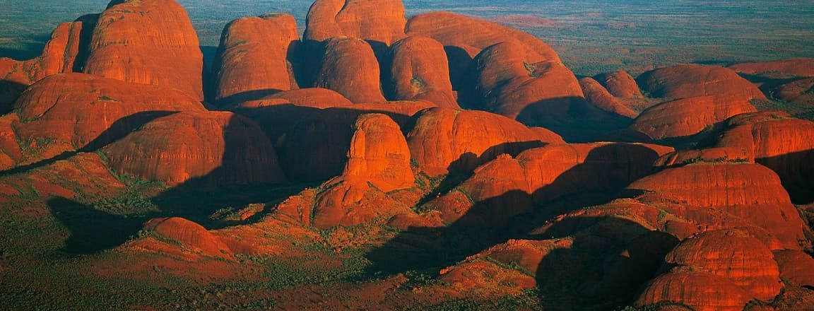
Kata Tjuta is one of the most breathtaking natural landmarks in Australia and a must-visit highlight of the Uluru–Kata Tjuta National Park in the country’s Red Centre. Famous for its unique geological formations, striking desert scenery, and deep cultural significance to the Anangu Aboriginal people, Kata Tjuta offers travellers a truly unforgettable outback experience.
Formed over millions of years, these towering rock domes change colours throughout the day, glowing bright shades of red, orange, and purple during sunrise and sunset. Visitors come here to experience the raw beauty of Australia’s Red Centre, hike through dramatic desert valleys, and learn about one of the world’s oldest living cultures. Whether you are a nature lover, photographer, or adventure seeker, this guide will help you discover the best things to do, when to visit, and how to plan your trip to Kata Tjuta. Many travellers combine Kata Tjuta with Uluru as part of a Red Centre itinerary in popular Australia tour packages.
Where Is Kata Tjuta Located?
Kata Tjuta is located inside Uluru–Kata Tjuta National Park in the Northern Territory of Australia, about 50 km west of Uluru and roughly 460 km southwest of Alice Springs.
The closest gateway town is Yulara, home to Ayers Rock Resort and the main base for travellers exploring both Uluru and Kata Tjuta. Because the two landmarks are located within the same national park, visitors can easily explore them together during the same trip.
About Kata Tjuta
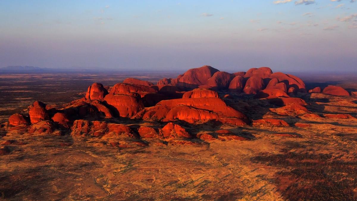
Nestled inside the Uluru-Kata Tjuta National Park in the Northern Territory, Kata Tjuta is one of the most unique places to visit in Australia. Also known as the Olgas, this spectacular formation is a sacred site for the Anangu people and holds deep cultural and spiritual significance. The Kata Tjuta rock formation covers an area of about 21 square kilometres and rises dramatically from the surrounding plains.
The name Kata Tjuta means “many heads” in the local Pitjantjatjara language, referring to the 36 massive domed rock formations that rise from the desert landscape. Kata Tjuta is recognised as a UNESCO World Heritage Site for both its natural beauty and cultural significance. The park is protected to preserve its fragile desert ecosystem and sacred Indigenous heritage. Visitors can explore designated walking trails such as the famous Valley of the Winds Walk while respecting cultural guidelines and conservation rules.
Top Things to Do in Kata Tjuta
1. Walk the Valley of the Winds
The Valley of the Winds Walk is the most famous hiking trail at Kata Tjuta. This spectacular trail passes through narrow valleys between the massive domes and offers breathtaking views of the surrounding desert landscape. The full circuit is about 7.4 km and includes scenic lookout points such as Karu Lookout and Karingana Lookout.
2. Explore Walpa Gorge
Walpa Gorge is a shorter and easier walking trail that takes visitors between two towering rock domes. The 2.6 km return walk leads through a natural gorge where wind and water have shaped the landscape over millions of years.
3. Watch Sunrise or Sunset
Sunrise and sunset are some of the most magical times to visit Kata Tjuta. As the sunlight changes, the massive domes shift in colour from deep red to glowing orange and purple.
4. Take Scenic Photography
Kata Tjuta is a paradise for photographers. The dramatic rock domes, wide desert plains, and constantly changing light create stunning photography opportunities throughout the day, especially from lookout points and walking trails.
5. Learn About Aboriginal Culture
Kata Tjuta is a sacred site for the Anangu Aboriginal people. Visitors can learn about Indigenous culture, traditions, and the spiritual significance of the landscape through interpretive signs and guided cultural tours offered within the park.
6. Enjoy a Desert Scenic Drive
Driving through Uluru-Kata Tjuta National Park offers incredible views of the Red Centre’s vast desert scenery. The drive from Uluru to Kata Tjuta provides multiple scenic stops where travellers can admire the towering domes rising from the vast desert plains.
What’s Unique About Kata Tjuta?
1. A Group of 36 Giant Rock Domes
Unlike nearby Uluru, which is a single massive rock, Kata Tjuta consists of 36 enormous domes spread across about 21 square kilometres. These rounded formations create a dramatic and unusual desert landscape.
2. Meaning “Many Heads”
The name Kata Tjuta comes from the Pitjantjatjara language and means “many heads". The name perfectly describes the cluster of domed rocks rising from the desert plains.
3. Taller Than Uluru
The tallest dome, Mount Olga, rises about 546 metres above the surrounding plains, making it even taller than Uluru. This gives the formation a towering presence within the vast outback landscape.
4. Ancient Geological Formation
Kata Tjuta formed over 500 million years ago through natural geological processes, including erosion and sediment compression. The rocks are made mainly of conglomerate stone, containing pebbles and rocks cemented together over millions of years.
5. Sacred Aboriginal Site
The domes hold deep spiritual and cultural significance for the Anangu Aboriginal people, the traditional custodians of the land. Many areas are considered sacred and are connected to ancient Dreamtime (Tjukurpa) stories.
6. Famous Valley of the Winds Walk
One of the most unique experiences at Kata Tjuta is the Valley of the Winds Walk, a scenic hiking trail that passes through narrow valleys between the towering domes and offers breathtaking views of the desert landscape.
7. Changing Colours at Sunrise and Sunset
Like many landmarks in Australia’s Red Centre, the rocks of Kata Tjuta change colours throughout the day, glowing deep red, orange, and purple depending on the sunlight. This makes sunrise and sunset some of the most magical times to visit.
Best Viewpoints in Kata Tjuta
Some of the best viewpoints to admire the massive domes include:
- Kata Tjuta Dune Viewing Area: The most popular viewpoint for sunrise and sunset photography, offering panoramic views of the domes rising from the desert.
- Karu Lookout: The first major viewpoint along the Valley of the Winds walk.
- Karingana Lookout: A spectacular vantage point offering views deep into the heart of the rock formations.
Kata Tjuta Visitors Information
- Location: Kata Tjuta is located within Uluru-Kata Tjuta National Park in the Northern Territory of Australia, about 50 km west of Uluru.
- Distance from City Centre: Approximately 460 km southwest of Alice Springs, the nearest major town in central Australia.
Opening Hours
- Park access: Gates open one hour before sunrise and close one hour after sunset (exact times vary by season and are posted at the park entrance)
- Valley of the Winds: Closes after 11:00 AM when temperatures exceed 36°C (generally October to April)
- Cultural Centre: Generally 7:00 AM – 6:00 PM daily
Kata Tjuta Entry Fees & Permits
Activity | Cost |
| Park entry pass (3 days) | AUD 38 (₹2,100 approx.) per adult |
| Children under 16 | Free |
| Ranger-led guided tours | Included with park entry |
| Ayers Rock Resort accommodation | Varies by property |
The park entry pass is valid for three consecutive days and covers both Uluru and Kata Tjuta. There is no separate fee for individual walks.
Best Time to Visit Kata Tjuta
Season | Months | Temperature | Ideal For |
| Autumn & Winter | May–Aug | 15–25°C | Hiking and clear sunrise/sunset views |
| Spring | Sep – Oct | 20–30°C | Wildflowers, photography, and morning walks |
| Summer | Nov – Mar | 30–40°C+ | Dramatic storms and rare desert waterfalls |
Best Time of Day
- Arrive at the Dune Viewing Area before sunrise for the most vivid colour on the rock faces
- Begin the Valley of the Winds walk at first light to complete it before midday heat restrictions apply.
How to Reach Kata Tjuta
The easiest way to reach Kata Tjuta is by travelling through the nearby town of Yulara, which serves as the gateway to Uluru-Kata Tjuta National Park.
- By Air: The nearest airport is Ayers Rock Airport, located around 50 km from Kata Tjuta near the resort town of Yulara. Regular flights connect the airport with major Australian cities such as Sydney, Melbourne, and Brisbane.
- By Car: Visitors can drive from Alice Springs via the Lasseter Highway, a journey of about 460 km (around 5–6 hours). The road is sealed and suitable for regular vehicles.
- From Uluru, Kata Tjuta is about 40–50 minutes by car from Uluru, making it easy to visit both landmarks in a single trip.
- By Guided Tour: Many organised tours depart from Yulara and include transportation, guided walks through the Valley of the Winds, and sunset viewing experiences.
Where to Stay Near Kata Tjuta
All accommodation in the immediate area is located at Yulara (Ayers Rock Resort), approximately 25 km from Kata Tjuta.
- Sails in the Desert – The resort's premium hotel, with a pool, full restaurant, and gallery featuring Anangu artwork
- Desert Gardens Hotel – Mid-range hotel surrounded by native gardens, a short walk from the resort centre
- Emu Walk Apartments – Self-contained apartments ideal for families or groups
- Outback Pioneer Hotel – A budget-friendly option with a lively BBQ restaurant and communal areas
- Ayers Rock Campground – The only camping option in the area, with powered and unpowered sites, kitchen facilities, and a pool
Things to Know Before Visiting
- Purchase your park pass online in advance through the Parks Australia website to avoid queuing at the gate.
- Do not attempt the Valley of the Winds loop after the 11:00 AM closure in hot weather, as heat exhaustion is a genuine risk.
- Photography of certain areas is prohibited out of respect for Anangu sacred law.
- Mobile phone coverage is limited to the Yulara resort area; do not rely on navigation apps inside the park.
- All wildlife is protected; do not feed or approach any animals
Conclusion: Why Kata Tjuta Is Worth Visiting
Whether you are watching the domes glow at sunrise, hiking through the Valley of the Winds, or learning about ancient Aboriginal culture, Kata Tjuta offers one of the most unforgettable experiences in Australia’s Red Centre. Its towering rock domes, scenic walking trails, and deep Aboriginal cultural significance make it a truly unique destination. From exploring the famous Valley of the Winds to watching the domes glow during sunrise and sunset, every moment here reveals the raw beauty of the Australian outback.
FAQs
1. Where is Kata Tjuta located?
Kata Tjuta is located in Uluru–Kata Tjuta National Park in Australia’s Northern Territory, about 460 km southwest of Alice Springs and around 50 km west of Uluru.
2. Can I climb at Kata Tjuta?
No, climbing is not allowed at Kata Tjuta. The area is a sacred site for the Anangu Aboriginal people, and visitors must stay on designated walking trails such as the Valley of the Winds and Walpa Gorge walks.
3. How long should I spend at Kata Tjuta?
Most visitors spend 2–4 hours exploring the main trails and viewpoints. However, half a day allows enough time to complete the Valley of the Winds walk and enjoy the scenic lookouts.
4. Is there public transport to Kata Tjuta?
There is no regular public transport directly to Kata Tjuta. Visitors usually travel by rental car, guided tour, or shuttle services from Yulara or Ayers Rock Resort.
5. What is the entry fee to Kata Tjuta?
Entry is included in the Uluru–Kata Tjuta National Park pass, which costs about AUD $38 (₹2,100 approx.) per adult for a 3-day pass, while children under 16 enter for free.

